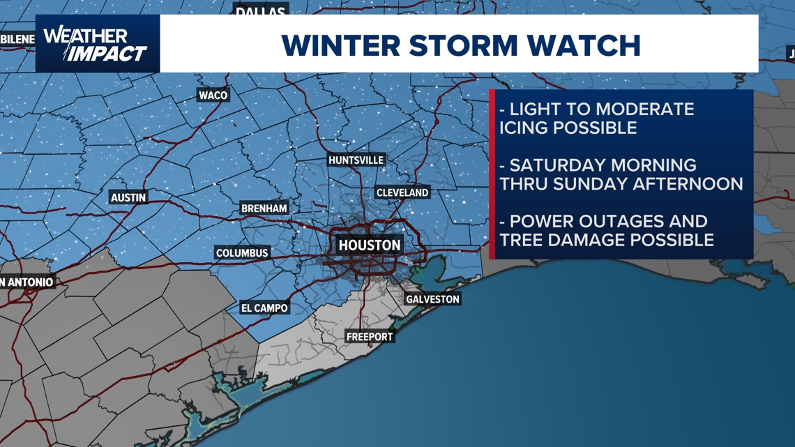
HOUSTON — It’s still a few days away, but confidence is increasing that southeast Texas could see significant winter weather impacts this weekend and into early next week. Due to the forecast models’ predictions, the Weather Impact Alert has been extended to Saturday, Sunday, and Monday.
KHOU 11 meteorologists are closely monitoring a setup that could bring ice, freezing temperatures, and hazardous travel conditions to the Houston area. While winter weather is not guaranteed, the necessary ingredients are in place if conditions align.
The National Weather Service announced that a Winter Storm Watch will be in effect for the Houston area from Saturday morning through Sunday afternoon. They’re expecting heavy mixed precipitation and ice to accumulate on the roads. The conditions could cause power outages, downed trees and dangerous travel conditions.
Also, an Extreme Cold Watch will be in effect from Saturday night through Monday morning. Wind chills as low as 5 to 15 degrees are possible. The coldest temperatures are expected Sunday night into Monday morning and a hard freeze is possible Saturday night and Sunday night.
The concern centers on two key components expected to move into the region:
This system is expected to have a significant impact on much of Texas, with notable effects already likely in north and west Houston, and the potential for ripple effects across Southeast Texas.
Friday is the final calm and mild day before conditions begin to change. High temperatures are expected to reach the upper 60s, with quiet weather during the day.
However, attention is already turning to the winter system developing to the west and north. Forecast confidence continues to grow that winter weather impacts could begin Saturday, making Friday an important day to prepare before conditions deteriorate.
Saturday marks the start of significant winter weather concerns across Texas. Temperatures will drop sharply into the 30s, with readings continuing to fall throughout the day.
Forecast models indicate rain could begin transitioning to a wintry mix as temperatures fall toward freezing during the afternoon. From that point forward, ice becomes a growing concern, especially on roads and elevated surfaces.
This system is expected to produce widespread ice across central and north Texas, where heavier accumulations could damage power lines and transmission equipment. Even if icing in the Houston area is lighter, power outages remain a concern if grid infrastructure north of the region is affected.
Travel impacts are likely to begin developing Saturday, particularly later in the day and into the evening.
Sunday is shaping up to be the most dangerous day in this forecast.
Some locations in southeast Texas may not rise above freezing all day, with temperatures hovering near or below 32 degrees. Wintry precipitation continues, with freezing rain and ice remaining the primary threats.
Ice accumulation could make travel hazardous or even impossible in spots, especially on untreated roads. Power outages are a concern, particularly north of Houston, where ice accumulation could be heavier and longer-lasting.
This is a statewide event, with much of Texas dealing with snow, ice, or both. Conditions elsewhere in the state could continue to impact southeast Texas through power transmission disruptions and travel delays.
Winter weather concerns continue into Monday as the system transitions from active precipitation into a hard freeze.
While wintry precipitation may taper off, lingering moisture on roads and surfaces could refreeze, creating dangerous black ice conditions during the morning hours. Travel impacts may persist into Monday afternoon before temperatures begin to recover.
Freezing temperatures are expected to remain in place long enough to stress homes, infrastructure, and the power grid. Overall, winter weather impacts are expected to last from Saturday through Monday, making this a prolonged and potentially treacherous stretch for the region.
Forecast models currently show areas shaded in pink across parts of Texas from Saturday into Sunday, indicating zones where rain could transition into ice. This includes the potential for freezing rain and sleet, which are especially dangerous due to rapid ice buildup.
The European model currently suggests a slightly better scenario locally for Houston, while the American (GFS) model is more aggressive, pushing ice potential farther south toward the coast. Meteorologists caution against focusing on exact accumulation numbers, as details will continue to evolve.
Even light ice accumulation can cause major travel problems, while heavier ice farther north could lead to extended power outages, affecting regions well beyond where ice actually falls.
Significant travel disruptions are possible across Texas and much of the country this weekend. Air travel delays are likely, especially from late Saturday through Sunday and into Monday morning.
Saturday morning into early afternoon may be the least disruptive window, but conditions are expected to worsen as colder air moves in.
This forecast is still several days out, and timing and impacts could change, but the setup is a classic one that demands close monitoring. Meteorologists will continue refining the forecast as confidence increases.
Residents are encouraged to check back regularly on-air and online as the Weather Impact Alert weekend approaches.
To stream KHOU 11 on your phone, you need the KHOU 11 app.
Next up in 5
Example video title will go here for this video
Next up in 5
Example video title will go here for this video
In Other News


