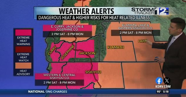
Our heat wave arrives tomorrow with 100s likely for many areas westside in Southern Oregon and Northern California.
Tonight: Skies remain clear overnight with mild lows for our Saturday morning. Temperatures fall into the 60s for westside valleys and in the 50s for the Klamath Basin. Wind should become calm areas inland through the night, with the exception of the coast. Lows along the coast in the 60s.
Tomorrow: We’ll see ample sunshine for the region again tomorrow. It’ll be much hotter though in the afternoon. Highs temperatures will climb into the triple-digits for most spots in our westside valleys. On the eastside, highs will make it into the middle to upper 90s. Along the coast, we’ll see gusty winds and fairly warm temperatures. The Brookings area will see the warmest weather thanks to the Chetco Effect with highs once again making it into the 80s. For inland areas, expect valley winds to pick up a bit for the afternoon and early evening hours.
An EXTREME HEAT WARNING has been issued for Eastern Curry, Josephine, Jackson and Western and Central Siskiyou Counties from 2 PM Saturday to 8 PM Monday. Click on the ‘Alerts’ tab above for more details.
A HEAT ADVISORY has been issued for Klamath, Lake, and Eastern Siskiyou Counties east of the Cascades from 2 PM Saturday to 8 PM Monday. Click on the ‘Alerts’ tab above for more details.
Extended: The heat will continue this weekend with temperatures bumping up even a bit more for Sunday. Highs will be into the 100s in our westside valleys with temperatures pushing 100° in the Klamath Basin. Be sure to stay cool and stay hydrated as this heat wave continues right into the workweek. We’ll need to keep an eye on Sunday. It’s possible some isolated thunderstorms could pop-up on the eastside and in Northern California Sunday afternoon. The heat wave carries into early next week. We’ll likely see more days above 100 degrees in the Rogue Valley. This heat wave will also bring some much milder nights too.
As we get towards midweek, winds will shift along the coast. The lighter, onshore winds will bring back marine layer clouds and fog along with cooler temperatures. Meanwhile, inland areas will stay quite hot through Wednesday. By Thursday, temperatures will drop back a bit, but we could see some thunderstorms return to the region too.
Stay up to date on the forecast by tuning into our future newscasts or right here on KDRV.com.
Follow @KDRV12 on Facebook and @KDRV on Twitter for the latest news, sports, and weather in Southern Oregon and Northern California.
Chief Meteorologist
Matt Hoffman joined the NewsWatch 12 team as Chief Meteorologist back in January 2018.
{{description}}
Email notifications are only sent once a day, and only if there are new matching items.
{{description}}
Email notifications are only sent once a day, and only if there are new matching items.
Your browser is out of date and potentially vulnerable to security risks.
We recommend switching to one of the following browsers:


